
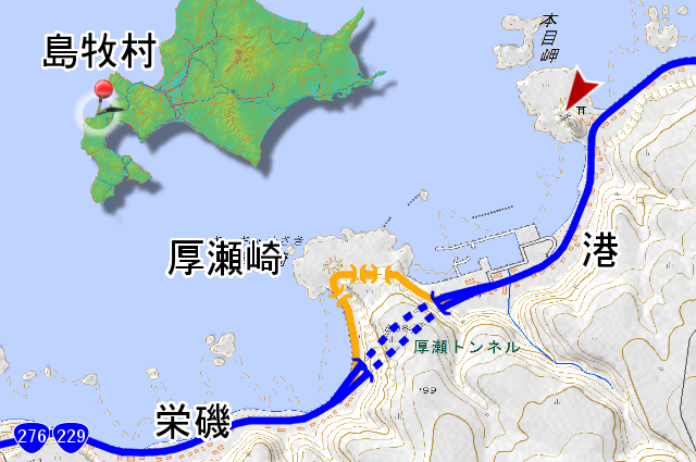
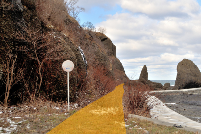
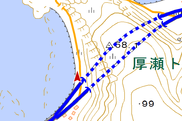
Shimamaki village (島牧村) is the fishing village that has been facing sea of Japan and Kariba moutains (狩場山地). Once upon a time, this village was prospering with the fishery of herring, but now this village has been depopulated, and a rank of the lebel financial capability index is the minimum level in Japan. Irrelevant to the it, landform has been placing tiny capes, bays and settlements. The old road that hold in Cape Atchase(厚瀬崎, Atchase-zaki) located between Minato (港) and Sakaeiso (栄磯) is todays arena. I’m not interested in abolishing road in this year, so I drop in during my boom fukuroma (袋澗, one of fishery ruins) tours. By the way, “Minato” do NOT mean “port” but the address (port called “minato” (港) in Japanese).

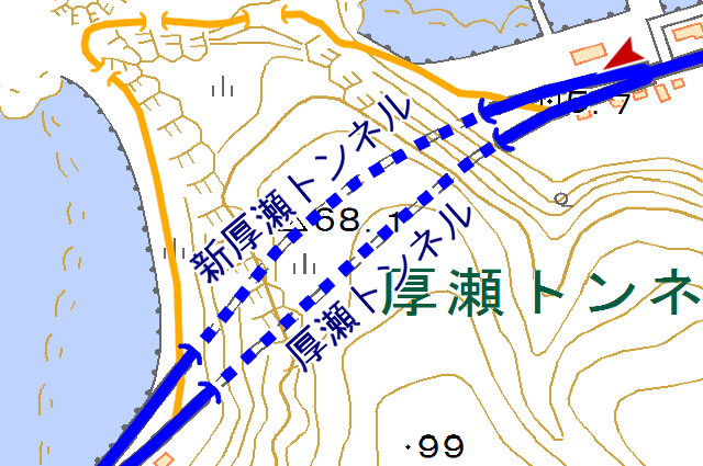
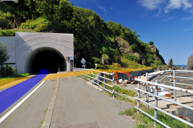
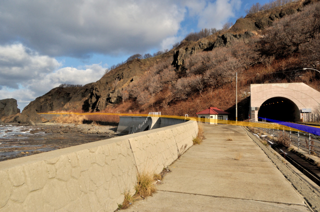
Minato side of Cape Atchase. left of picture, the land side tunnel is atchase tunnnel (厚瀬トンネル, atchase tonnneru) completed in . 5.5m width, 4.5m height. It’s normal size of national road No.229 (国道229号) of their era. 5.5m of tow lane, that is 2.75m one lane is the minimum width that “road structure ordinance” (道路構造令, dōrokōzōrē) approved. I can understand it’s less traffic very much in the past, because the road structure ordinance stipulate width by traffic. Reasonable at completed this tunnel, the road between Setana town(せたな町, setana chō) and this town that through Cape Motuta (茂津多岬, motsuta misaki) under construction. Simamaki village is dead end view from Suttsu town(寿都町, Suttsu chō), so in fact, though it was national road, I think traffic was little. Construction was impregnable, but it’s opened in 1976. I think the road was needing new tunnel circumstance in increase traffic and speed. In shin atchase tunnel (新厚瀬トンネル) completed beside the sea side of old one, and it have become for each inbound and outbound respectively.
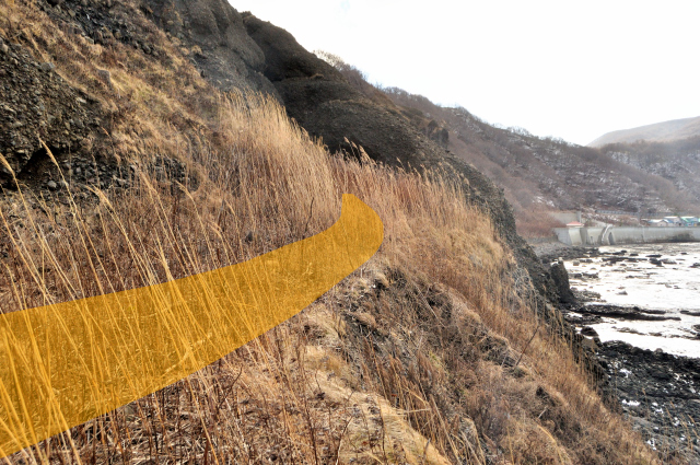
Old way continues side of sin-atchase tunnel (新厚瀬トンネル) . As much as possible do not make up downs and tunnels, road is being surrounded around cape spontaneously.
I think nobody notice that here is road without discolor road closed sign set in entrance of the old road. I think so because hard bush, no footprint, and no atmosphere. I think not need the sign because the road became so. Rather road became nature almost, but we are exposed it’s road by sign.
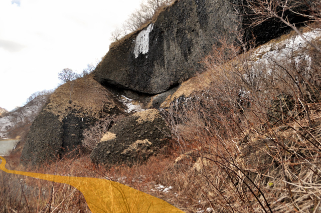
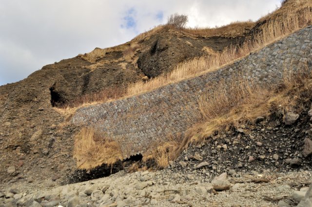
The cape is Surrounded by cliffs, and the road has made under this. The criff is consists of fragile agglomerate, so many rocks that various sizes has been fallen. I have fear suddenly because I am concerned how large cracks in outcrop.

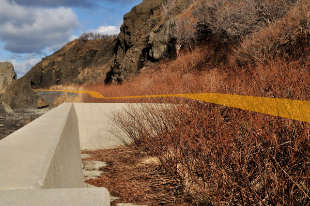
It looks no spaces so the road reclaimed with stone wall followed by many. White concrete in front of the stone wall is road for the construction of breakwaters. There are cliffs and bushes behind the stone wall, but in front, there is new construction. Then the stone wall looks border of the human world and nature world.
The road curved to left gently. I can observe from current road up to here. What has become the destination. Are the tunnels existing?
Curve ahead at chase No.1 tunnel (厚瀬1号トンネル) waits for me. Today, I made 360° panorama photo on a trial basis. Please enjoy it with drag. (You must need FLASH. Almost smart phone can’t use it. Sorry.) No.1 tunnel is slightly smaller but longest tunnel in 3 tunnels on this old road. Completion year is blank on”Current state working papers” (現況調書, genkyōchōsho), other tunes too.
The top image reveals the state of here. Its excavation without support. Stone wall and excavation without support tunnel, go together, isn’t it?
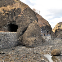
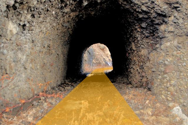
After tunnel, embankment slope is still stone wall. Embankment that broken place has restored by huge sandbag. I don’t think the intention is to open the road, why they restored? It’s atchase No.2 tunnel 厚瀬2号トンネル) over there.

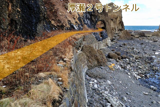
It’s atchase No.2 tunnel (厚瀬2号トンネル). Rear side entrance a little bit broken.
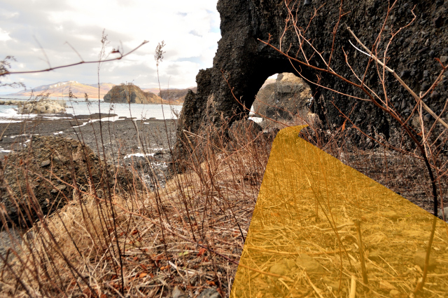
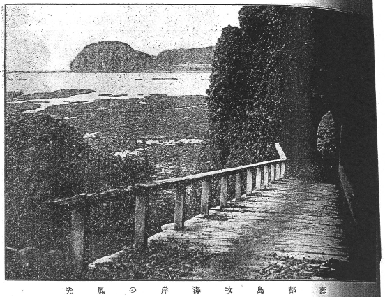
The landscape of after through No.2 tunnel. Right monochrome photo is published in “Commemorate Hokkaido 50yeras from start “(開道五十年記念北海道, kaidō gojūnen Kinen hokkaidō). Sorry for the copy was not good at because it’s too thick book. This book, published in 1918, so the tunnel exists from about 1century ago. Scrutinize carefully, there is excavated to lower elevation and narrow width than now, and it looks not for the car or cart but for pedestrian. The boardwalk is sloping up to here.
The road is filled by talus. Maybe there is many sediment as the road became slope from boardwalk period.
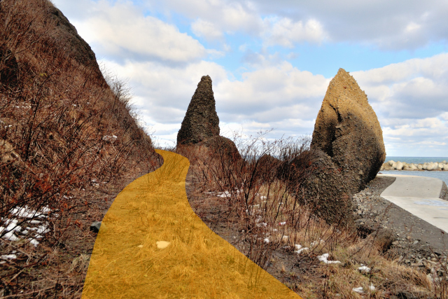
Near here is the tip of the Cape Atchase. There has been a large rock tower just right side. I arrive west slope of the cape to pass deep col and sharp curve, then I can see Sakaeiso (栄磯).
Incidentally, Atchase (厚瀬) refers to Minato (港) originally, but In administration changed to current landname Minato (港) . Sakaeiso(栄磯) was calling Kaijishi (or kaijishi, 飼鹿) until this time. I think “atchase” likes Ainu language, but meaning not explained by Hosei Nagada and Hidezo Yamada In “tōzai ezo sansen chiri torishirabezu” (東西蝦夷山川地理取調図) , Minato is Achiyarase , so I think it isll in Atchase”, I thi related small river. “saikō ezo nisshi” (再航蝦夷日誌) has described “there is a little waterfall in Atchase”, I think Charase means this water fall. Maybe there are so many elm around here, accordingly Atcharase , Shorten atchase.
So far I walked among the strong wind, and dripped nasal mucus. But now when pass the cape and went to southern slope , it’s hot because no wind but rather strong sunshine. I have dead if I’m a rabbit because intense conversion of the environment. Bush increase by sunshine, so hard to walk through.


For now I have arrived in the No.3 tunnel (厚瀬3号トンネル) .
I have just escaped to seashore because I’m sick of bush that continued after the tunnel. I’m not noticing on the road, I was walking on the splendid stone wall.
The stone wall is continuing after tunnel. The wall impressed me with stone wall is more beautiful than tunnels.
The bush continues to just before merge to current road, so I eventually didn’t walk on the road. However stone wall continue too, I became a newbe stone wall geek so I glad.
I have back current road. I read this old road built in part of between Suttsu (寿都) and Shimamaki(島牧) road construction started in . In bus start going here, the road had remade for car before this year. People depend on marine traffic before complete the road, monochrome photo was taken in just good timing. The road guard land traffic with tunnels and stone walls from the tidal wave until year of attyase tunnel onpened () about 40 years’ worth of scar remain as many epair marks of stone walls. It’s from half century. The road was abolished by people reasons. But sea attacks with storm and tsunami independently of people reasons. and damage is conspicuous on the stone wall. Old road in Cape Atchase that has remain of brilliant fishery piriod will fade away.
infomation of this entry
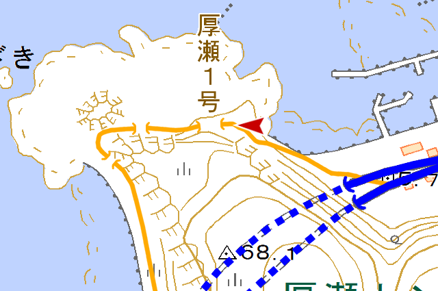
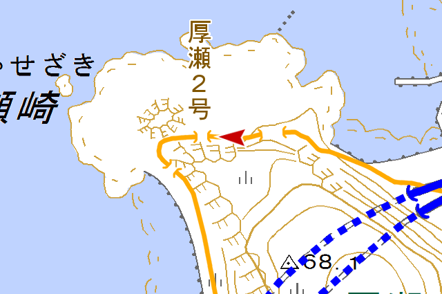
主要地点の地図
参考文献
- zwiebel、『北海道 道路トンネルデータベース 国道229号 – 北海道 道路レポート"カントリーロード"』(http://web.archive.org/web/20111016202224/http://hokkaido-douro.net/tunnel/R229/index.html)
- 島牧村教育委員会(編)、『島牧村史』、島牧村、1990年
- 北海道、『橋梁現況調書 昭和39年3月31日現在』、北海道、1964年
- 北海道開発局、『橋梁現況調書 昭和41年3月31日現在』、北海道開発局、1966年
- 北海道道路史調査会(編集)、『北海道道路史 路線史編』、北海道道路史調査会、1990年
変更履歴
- 誤字修正